
Early History of Odiorne's Point
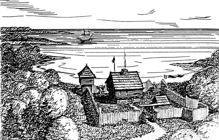
The first recorded settlement and fortification at this site was Pannaway Plantation, built by David Thompson in 1623, as the first English settlement in the Piscataqua River area. A large stone structure was probably built, called the "Great House", with other additional structures. This may have been a trading post used by the first settlers. The Thompson group relocated to Boston Harbor in 1627. A log garrison house was probably built around 1670 by the Odiorne family, but no archaeological evidence exists to prove or disprove any type of building materials used in the early settlements here. A gravel pit operation in the early 1900s obliterated any trace of the original settlement sites.
The area was used almost exclusively for farming up through the 1880s, after which several cottages, including the Sagamore House resort hotel on Frost Point, were built for summer residences and tourists. A small Life-Saving Station was built at Odiorne's Point in 1894, in use until 1906. It mainly served as a foot-patrol check-in station for the main station at Wallis Sands in Rye. The stone breakwater at Frost Point was built in 1902 by the U.S. Army Corps of Engineers to protect the small-craft anchorage in Little Harbor.

World War I Era
No fortifications were planned for this location during World War I. A temporary wartime secondary fire-control field station (B" Battery Hunter, Fort Stark) was established on Odiorne Point in 1917-18. Later, two truck-mounted 60-inch Sperry searchlights were set up at Frost Point in 1920 (harbor positions #1 and #2). They were withdrawn in 1921 and shipped to Fort Totten, NY. The 197th Coast Artillery Regiment (Anti-Aircraft), New Hampshire National Guard conducted yearly summer training exercises nearby at Rye Harbor after 1922.
World War II History
The onset of World War II saw the need for increased protection of Portsmouth Harbor that could not be met by any of the other existing forts of the area. Fort Foster only had room for one new battery, but there was no space available at any of the other forts without destroying existing batteries, which was deemed unacceptable. The Coast Artillery had decided that the better solution was land between Odiorne's Point and Frost Point in Rye. This was to become Fort Dearborn. Two batteries of modern twin 6-inch guns (standard 200-series) with a range of 15 miles, and a single battery of twin 16-inch guns (100-series) having a range of 25 miles, were planned as part of the new defenses. At the time, the land was home to several fashionable summer houses on 22 contiguous lots. In early 1942 the federal government condemned and purchased all of the land between the two points (264.9 acres) and gave all residents 30 days to pack up and leave. In those days, market conditions were depressed, and no property could get top dollar. To this day the surviving "old-timers" and their descendants still feel bitter about the whole affair, mostly because they did not get a chance to reclaim any of their holdings back in the 1950s when the military left. In addition, the coastal highway was also closed to the public, which required travelers to use another more circuitous route to travel along the coast between Portsmouth and Hampton.
The first emplacement that was built here was a temporary one, consisting of four 155mm guns, Model 1918M1, serials 872, 783, 1080, 235 (Minneapolis Steel and Machine Co.), on tractor-drawn carriages, Model 1918M1, serials 572, 694, 328, 746 (Minneapolis Steel and Machine Co.), set on concrete "Panama mounts" at Odiorne's Point. Three of these mounts are still visible today (the fourth is buried). The center of the gun carriage was placed over the central "hub" of the mount. The towing trails of the carriage were set on the steel rails on the outer ring to allow for a full 360ş field of fire. The guns were originally temporarily set up at Frost Point in field emplacements in late 1941. Four earth-covered concrete magazines were built behind the gun mounts, two forward and two rear, along with a Battery Commander's Station. These structures no longer exist, however the concrete foundation of the #2 forward magazine can still be found. This battery remained in place until the new permanent batteries were completed in 1944.


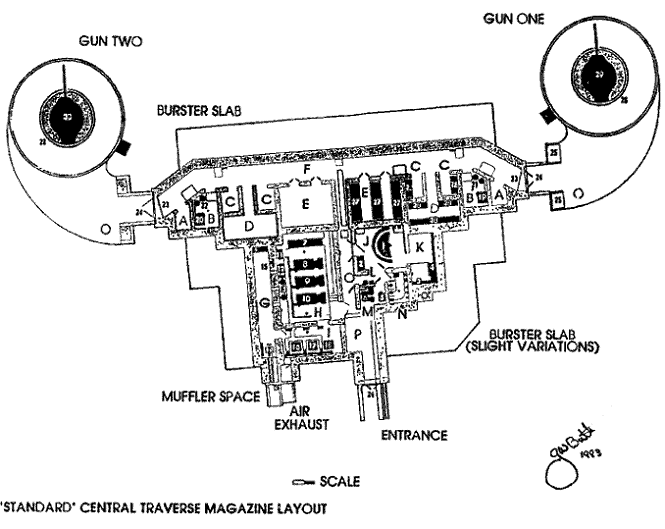
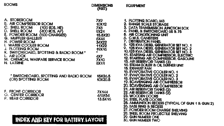
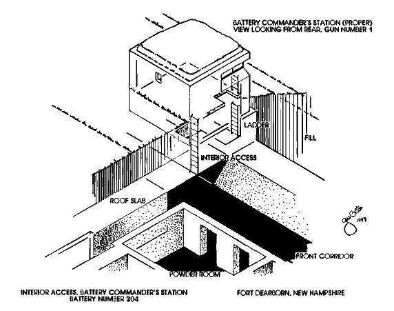
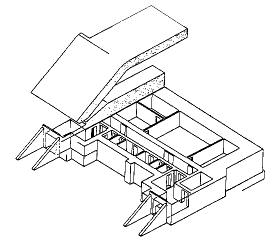
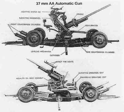
Construction was started in 1942 on the concrete emplacements for the new shielded M1 6-inch guns, serials 22, 23 (Watervliet Arsenal), on M3 barbette carriages, serials 14, 15 (Watertown Arsenal), for Battery Construction No. 204 at Odiorne's Point. Its proposed name was Battery M. H. Barry in honor of Lt. Colonel Michael H. Barry. The layout of Battery 204 differed from most other similar batteries, in that the Battery Commander's Station was built directly on top of the magazine, and that access to the station was by interior ladder. This design was later deemed dangerous, as a direct hit on the Commander's Station could possibly reach the entire magazine. All subsequent 200-series batteries, including Battery 205 at Fort Foster, would have their Commander's Station built as a separate structure, a safe distance away from the magazine. Two automatic 40mm mobile AA guns, Model M2, and two .50-caliber heavy machine guns were emplaced around the battery for land and air defense.

See Sitka's 6-inch Guns, by Matt Hunter, and also The 6-inch Shield Gun, by Andy Bennett,
for more photos and information on this type of gun.
The 50-caliber MKII M1 Navy guns that were available to the 100-Series Battery Program came from the "South Dakota" Class battleships of 1917, and the "Lexington" (CC1) Class heavy cruisers that were scrapped to comply with the 1922 Washington Naval Treaty. The gun tubes, serials 99, 104 (Watervliet Arsenal), were mounted on M5 barbette carriages, serials 56, 57 (Watertown Arsenal), in protective concrete casemates. This battery was initially named Battery Construction No. 103, later renamed Battery Seaman in honor of Colonel Claudius M. Seaman. Steel-plate shields were added in 1946. The Battery Commander's (BC) and Gun Group Commander's (G1) Observation Stations were built on top of the battery, similar to Battery 204, except for exterior access. The Gun Group Command Post was located in a small concrete building behind the battery, transferred from Fort Stark in 1942. The plotting room for Battery Seaman was built as a separate casemate behind the battery due to the shock of the firing of a gun that large. During the war, four automatic 40mm mobile AA guns, Model M2, and four .50-caliber heavy machine guns were emplaced around the battery for land and air defense.


Navy MK II 16-inch gun, on Army proof-mount barbette carriage.
This may be the last surviving example of this type of weapon.
Located at Aberdeen Proving Ground, Aberdeen, Maryland.
In late 1942 construction was begun on fourteen Fire-control Stations (or Base-end Stations) that were needed for the new gun batteries. These ranged between 25 miles north and 25 miles south of Frost Point, the maximum range for the 16-inch guns of Battery Seaman. Five of those concrete towers still exist today (as of 2008), located at Moody Point, Pulpit Rock, Great Boars Head, Appledore Island, and Halibut Point. (See World War II Towers).
In 1943 the entire reservation was formally named Fort Dearborn, reflecting Henry Dearborn from Hampton, N.H., a major in the American Revolution, the Secretary of War during 1801-09, and a Major General in the War of 1812. (see also N.H. war heroes) Construction was finished on several new buildings, including a gate house by the bridge over Seavey Creek, barracks, Officers' quarters, chapel, commissary, and a TNT storage magazine used for the harbor mines. A 60-inch Sperry searchlight on a steel-frame tower (position #9) and an SCR-268 radar were located at Odiorne's Point. (See also World War II Towers). Most new construction was alongside the highway, including several Quonset huts. Several of the original houses that were not immediately razed were used as barracks or Officers' quarters, but all were demolished after the war, with the exception of the Odiorne Farmhouse (built 1800), and the Sugden House (built 1921), which is now the Seacoast Science Center and the park visitor center. The fort was garrisoned by elements of the 22nd Coast Artillery Regiment (Harbor Defense), U.S. Army. Barbed-wire security fencing (dead-lines) around the Seavey Creek marshes is still visible today. Anti-Motor Torpedo Boat Battery 951 was constructed in 1943 off post at Pulpit Rock Camp, just to the south of Odiorne's Point. It consisted of two shielded 90mm M1 guns on fixed M3 mounts, two mobile 90mm M1A1 guns, and four .50-caliber heavy machine guns. It was not officially part of Fort Dearborn, but rather under the umbrella of the Portsmouth Harbor Defense Command. (See Pulpit Rock Camp). AMTB Battery 351 was also at Pulpit Rock Camp, consisting of two 37mm mobile AA guns (later replaced with two 40mm M2 mobile AA guns), and a dedicated searchlight.

In June 1944, Batteries 204 and Seaman were completed and proof-fired with several rounds for each gun. This was the only time that they were ever fired. Windows were reportedly shattered as far away as downtown Portsmouth. Battery Seaman was then moth-balled and placed on caretaker status to finish out the war. Battery Hunter at Fort Stark was then retired, as it was no longer needed. Battery 204 remained active until the end of the war.

Cold War Period
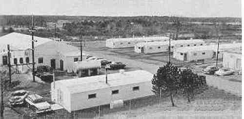
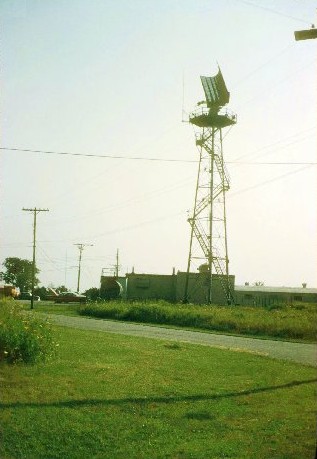
In 1946 the ocean side of the reservation across the highway was fenced-in to allow the public re-opening of the coastal roadway. All four 90mm guns of Battery 951 at Pulpit Rock were removed and placed in storage inside Battery Seaman. In 1947 the 954th Coast Artillery Battery (Harbor Defense), New Hampshire National Guard, Portsmouth, was formed with 101 men to operate Battery 204. The 954th Battery, along with its sister unit the 978th C.A. Battery (HD) of Dover, was a part of the 237th Coast Artillery Battalion (Harbor Defense), New Hampshire National Guard, headquartered in Dover. Units of the 281st Coast Artillery Battalion (Harbor Defense) were also present here at Fort Dearborn during this time. However, by 1948 the fort was deactivated and all the guns were removed. In 1949 the fort was declared surplus property, and the 954th Battery, as well as the entire 237th Battalion, was redesignated as Field Artillery, as the U.S. Army Coast Artillery was formally abolished. The Seavey Creek parcel of the reservation (128.2 acres of the old Odiorne farmstead) was deeded by quitclaim to private landowners - not the original landowners, however - with the original farmhouse still intact. The U.S. Air Force took formal possession of 45.3 acres at Odiorne's Point in 1955, which it had been using since 1949. It was renamed Rye Air Force Station, used as an Air Defense Command (ADC) Air Defense Radar site for the 644th Aircraft Control and Warning (AC & W) Squadron, supporting the bombers and fighters of Portsmouth Air Force Base (1956 - 1990) in Newington, which was renamed Pease AFB in 1957. A mobile AN/TPS-1D radar unit was placed atop Battery 204 from 1955-57. The Sugden House was used as barracks for about 15 men. A fire station, mess hall, gate house, operations center, and other buildings were built by the Air Force. Some older Army buildings and Quonset Huts still extant at the time were also used. The Air Force personnel left in 1959, while retaining an easement of 0.3 acres for the Fort Dearborn Gap-Filler Annex Air Defense Radar site, operated remotely by the 762nd AC&W Squadron (later the 762nd Radar Squadron) from the North Truro Air Force Station in North Truro, Massachusetts. An AN/FPS-14 SAGE System "Gap-Filler" radar tower was built behind Battery 204 in 1957, which operated until 1968. Meanwhile, units of the New Hampshire National Guard used the Frost Point parcel (91.4 acres), still known as Fort Dearborn, for training purposes from 1949-53. Battery 204 was also designated as a Civil Defense shelter during these years. (Read a trip report by Scott Murdock, taken in May 1999, about the area's former Air Force radar stations and bases.)


Post Military Period
In 1961 the federal government transferred by quitclaim the Air Station (Odiorne's Point) parcel and the National Guard (Frost Point) parcel to the State of New Hampshire for use as a state park. All of the remaining military structures, including the radar tower, were demolished between 1971 and 1976. Many of the WWII concrete gun batteries and casemates were buried by gravel and soil fill by 1980. Fort Dearborn State Park was informally open to visitors in 1962, with interpretive programs beginning in 1973 (by then renamed Odiorne Point State Park to better convey the natural history of the area). The former Air Force fire station was used as the first visitor center for the park until 1976 when replaced by the Sugden House, which was enlarged in 1992 to become the Seacoast Science Center. The entrances of the gun batteries were exhumed in 1988, while the plotting room casemates are still entombed. The Seavey Creek parcel, with additional acreage, was sold to the State of New Hampshire in 1993, bringing the total State Park acreage today to 331.5 acres. The WWII-era TNT magazine is located on this parcel of land.
Admission to the park is charged per person, with an additional separate fee to visit the Seacoast Science Center. There is limited outside interpretation of some of the military structures, but additional information and photos are displayed inside the visitor center. There are picnic facilities and restrooms at Odiorne's Point, and an unsupervised non-swimming beach and boat launch/landing at Frost Point. Battery Seaman is partially open to visitors (gun casemates only), but has been heavily vandalized over the years. Battery 204 is currently closed to visitors. During the summer months, visitors should bring a copious supply of insect repellent, as the local mosquitos and black flies are reknown for their ferocious appetites!
Odiorne Point State Park official website from NH State Parks

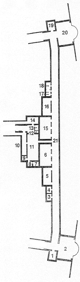
Map of Odiorne Point State Park.


1992 USGS Satellite Images of Odiorne Point State Park
Battery locations outlined in yellow.
Seacoast Science Center outlined in red.
Proceed to Photo Gallery ![]()
